Weather
We've added a comprehensive weather resources page.
One of the big questions people have this time of year is, "Are the passes going to be clear of snow by race day"? The short answer for `08 is yes. And for the record, in the past four years of mid-June N-to-S divide racing, there's been only one 50 foot stretch of snow-covered pass, period. That was in 2005 climbing out of California Park, down into Hahn's Peak Basin north of Steamboat Springs, CO.
We monitor SNOTEL (SNOpack TELemetry) data periodically and although April can still bring big snows along the Divide, we feel confident in publishing basin readings now as indicative of what we're gonna get. If you're a numbers person, a full report on the GDMBR-USA segment can be read here. We'll try to get a link to Canadian data asap.
The summary as of 3/31:
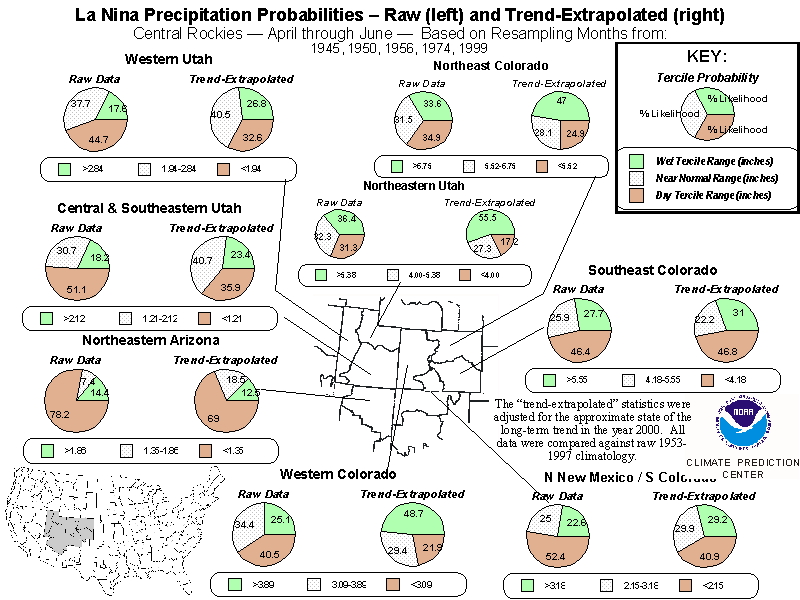
Canada experienced average to slightly above average snowfall in the Bow and Elk basins. Montana had a pretty average year. As much as 115% of normal snow fell in some parts of the Kootenai but Flathead is at 104% and Clark Fork, Upper Missouri were both normal. Idaho in the vicinity of the Tetons, Henry's Fork and the Wind Rivers varied from 10% above to at or below normal for the season. Wyoming's basins also had a normal year. Colorado had a big year most areas west of the front range. Yampa, Platte and Laramie basins were normal. Upper Colorado is at 125%. Gunnison is at 127%, Arkansas is at nearly 150% and Upper Rio Grande is at 135%. New Mexico had a big year in the North and a poor year to the South. Rio Chama matches Upper Rio Grande snowfall but to the south the Gila saw only 70% of norms. So, true to historical data, "West is best" (west side of the divide) if you depend on lots of snow for fun in the winter.
The Prognosis:
What does it all mean for divide racers? Conditions on course should be pretty average this year for most of the route with the exception of heightened thunderstorm activity along the areas of the Divide with above average snowfall. Expect severe afternoon storm cycles to be robust in SW MT, NE ID and from Steamboat Springs southward into northern NM as snowmelt/evaporation cycles feed convection. It's also uncertain what effect the Cascade's huge year (OR/WA) will have on the Divide. It could pump up the normally rich dew points even more along the west side of the divide, elevating June precip chances (overall) in MT. The strong-to-moderate La Nina we're under this year (now predicted well into summer), as well as the prevailing winds will be important predictors in what happens. For example, this La Nina precip model for CO confirms above avg. precip.
Dirt road conditions are often shaped by Spring weather (April/May). If sudden warm-ups get residents along the divide out working, recreating early then poor weather and rain mix with the activity, it can wreak havoc on the route surfaces. Last year was a weather/route-perfect year for Divide racing. We suspect is won't be quite so "tranquilo" this year but we can always hope...


Comments
snowpack 2008
i live in fernie, bc and have been into the upper flathead watershed near the US border (one of very few who has actually measured snowpack depth there recently), and can provide the following snowpack/pass info (as of April 26/08):
- high passes in the flathead and upper elk watersheds had 2-3 m of snow depth 1 month ago,
- a cold spring has resulted in very limited melting in region, with snowpack depths in the valley bottom still ~0.5 m in locations
situation can change significantly if warmer weather pattern establishes (esp. if warm rain occurs, although that may lead to major flooding and road/trail damage.), but to date it is the snowiest April in recent memory in these watersheds. more snow predicted this week.
snowpack update
Brazos Ridge in northern New Mexico
I was northbound (nobo) on the GDMBR last week (Thursday, June 12th) and I literally nearly got blown off Brazos Ridge in northern New Mexico. There were countless snow drifts and many snow fields, but the tire/feet sucking mud was endless. At one point the wind blew me up a 5% rocky road at 5 mph for about a 100 feet and I never pedaled a stroke. That was fun!
Then the road turned direction and a gust of wind picked me (170lbs) , the loaded bike (50+ lbs) and my trailer (18 lbs) with a load (45 lbs) up (airbourne) and threw me and the load off the road about 10 feet. Instinctively I tucked and rolled like a pig in a pile of shit and fortunately did not get injured. Unfortunately my derailleur hanger got bent and the derailleur was in between the spokes. I gingerly straightened the hanger so that the derailleur was away from the spokes and in a safe middle gear.
For several miles on either side of Brazos Ridge (more on the north side than to the south) the Forest Service "roads" are now creeks. Where it is dry there are gullies 2-3 feet deep with a narrow 1-2 foot wide level patch in the middle. The so-called rocky "unrideable" section just before you get to Brazos Ridge (sobo) is actually the best piece of real estate up there.
An angel sawyer on a motorcycle has bucked up a lot of the downfalls to the north of Brazos Ridge. They have also done a great job of punching paths through the many snowdrifts, but the downhill side of each drift it is wet, icy, and muddy (i.e., slippery).
I got as far as Horca, CO where I learned that 3 out of the 5 major passes in Colorado are still officially closed as of Friday, June 13th. The snow and mud are one thing, but the constant 30-40 mph winds with gusts to 60-70 mph really create a significant hazard. A few more gusts like the one that sent me and my load (almost 300 lbs total) airbourne and I would have been blown over the edge. That was at a little over 11,000 feet elevation. After that I hike-a-biked the rest of Brazos Ridge and was constantly ready to hit the deck and grap as much soggy terra unfirma as I could to keep from getting blown over the side of the mountain.
I know these racers are a lot younger and tougher than myself, but that was my experience. I wish them all well and safe travel. You can check out my web site (www.bikerbobonthegdmbr.com) where I have posted a lot of pictures of the New Mexico section that I just traveled nobo. I am working on getting captions attached to all the pictures and more details of the trip in my posts. I had hoped to meet some of the racers on the route this year, but for now I am off the route. I've had all the fun I can stand for now. As usually I am watching their progress by their reports, and I am very excited about the ability to track them with the SPOTs.
Current Weather on the GDMBR
At the bottom of my web site (www.bikerbobonthegdmbr.com) I have listed links to many weather stations along the GDMBR from Banff, AB to Columbus, NM (Antelope Wells is not a town, just a border crossing in the middle of nowhere). The links regularly update the temperature, sky conditions, and wind speed/direction. You can see at a glance how the weather is along the route. If you click on any of the widgets then you can get detailed forecasts, history, and sometimes radar and web cam views. Check it out.
Post new comment